Decision Support
Software & Data > Business Intelligence
Decision-making: spatial intelligence for all
Geographical decision-making for better management of your territories
Ciril GROUP places the geographic dimension at the heart of strategic decisions, combining creativity and technological innovation to stay one step ahead. With our dual expertise in Business Intelligence and Geographic Information Systems (GIS), we design high-performance, intuitive tools adapted to your management and territorial analysis needs, to better anticipate your requirements.
Our solutions add value to your strategic data, providing key analyses for informed decision-making. By integrating the geographical dimension and an innovative approach, we help you decipher your territories and make the most of your business data.

|
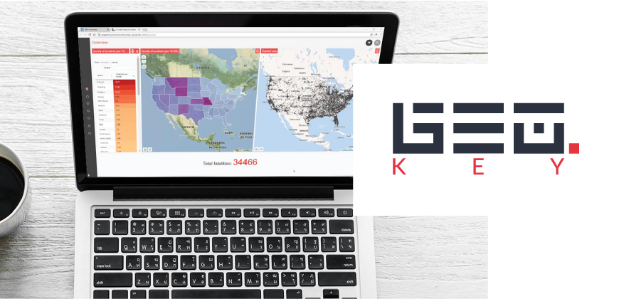
GEO Key: the cartocentric Business Intelligence solution
Geographic intelligence for decision-making.
GEO Key is an interoperable Geo-Business Intelligence solution that combines power and simplicity. It brings together the worlds of Business Intelligence and GIS, offering a cartocentric, intuitive and ergonomic approach.
- Advanced analysis and reporting: Leverage your geographic, business and contextual data for optimal decision-making.
- Customized dashboards: create interactive cartographic and statistical visualizations in just a few clicks.
- Total interoperability: connect your local, remote or real-time data via APIs and connectors.
- Enhanced accessibility: an ergonomic interface designed for experts and non-specialists alike.
Compatible with all GIS standards and data formats, GEO Key adapts to any environment. It can also be used to prepare customized datasets for even more precise analyses.
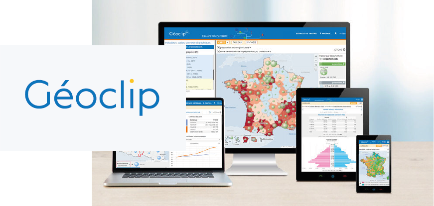
Géoclip: the decision-making tool for territorial observation
Intuitive, powerful geostatistical observatory
Géoclip is the reference tool for creatinggeostatistical observatories in web mode. It lets you explore, analyze, compare and share a wide range of localized indicators through high-quality cartographic and graphic representations, thanks to features tailored to the needs of statisticians and non-specialists alike:
- Thematic cartography: Represent your statistical data according to strict semiological rules for relevant analysis and retrieval.
- Edit territory portraits: Analyze a study area through highly meaningful data-visualizations, based on selected indicators, and compare them with a second territory and/or encompassing zonings.
- Dual-map comparison: Explore your territories over time or through different indicators with dual-map mode, which simultaneously displays two interconnected versions of your area from different perspectives.
- Intuitive, ergonomic interface: Navigate easily between analysis, mapping and reporting tools.
- Open data and data sharing: promote open data and communication within your organizations.
Géoclip promotes shared knowledge of territories and is a key lever for your geostatistical observation and communication projects.
Géoclip
Intuitive, powerful geostatistical observatory
Géoclip is the reference tool for creatinggeostatistical observatories in web mode. It lets you explore, analyze, compare and share a wide range of localized indicators through high-quality cartographic and graphic representations, thanks to features tailored to the needs of statisticians and non-specialists alike:
- Thematic cartography: Represent your statistical data according to strict semiological rules for relevant analysis and retrieval.
- Edit territory portraits: Analyze a study area through highly meaningful data-visualizations, based on selected indicators, and compare them with a second territory and/or encompassing zonings.
- Dual-map comparison: Explore your territories over time or through different indicators with dual-map mode, which simultaneously displays two interconnected versions of your area from different perspectives.
- Intuitive, ergonomic interface: Navigate easily between analysis, mapping and reporting tools.
- Open data and data sharing: promote open data and communication within your organizations.
Géoclip promotes shared knowledge of territories and is a key lever for your geostatistical observation and communication projects.